
Farmlands Trail Info:
- Difficulty: Easy (gradual elevation ascent of 40m).
- Infrastructure: Parking.
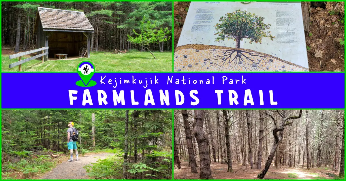
- Signage: 4 information panels which narrate a guided cultural & natural history of the area.
- Features: 1.5 km (30-minute) semi-looped hike up a drumlin to a plateau, the site of a 19th-century farm.
- Categories: #Backcountry, #Easy, #Family-Friendly, #Historic-Sites, #Kejimkujik, #Loop, #Old-Growth, #Short

Hiking Trail
The Farmlands trail is one of the shortest in the park, but that does not mean it lacks Kejimkujik’s natural charm. At 1.5km with a steady climb/descent, it’s an easy hike that can be accomplished in 30 leisurely minutes. These minimal requirements make this trail a good introduction to the park without a big time commitment, leaving plenty of your day to explore other areas of the park.
Like the Hemlocks & Hardwoods trail, this hike is like a self-guided tour where information panels guide you through each section, offering insights into what you are seeing around you at each point. Also like the Hemlocks & Hardwoods trail, this one is a semi-looped hike where the non-looped part of it is minimal.
The first half of the loop is a gradual ascent of 40m. This part of the trail describes how you are ascending a geologically ancient drumlin, a hill formed by the retreat of massive kilometer-thick glaciers that once covered Nova Scotia. This part of the trail begins the gradual ascent of the teardrop-shaped drumlin, its shallow soil inhabited by a specially adapted shallow-rooted pine forest that contrasts with later parts of the hike.
At the midway point, you’ll reach the trail’s namesake; the remaining farmlands from a mid-nineteenth-century farm. A reconstructed barn and remnants of original farm equipment are all that remain of Peter Rogers’ homestead built atop this drumlin. Be sure to explore the subtleties of this area as the information panels suggest. It’s also a good place to take a break, provided you’re not there at high noon as there wouldn’t be much in the way of shade.
The second half of the loop is a steady descent where you’ll walk through the stages of the forest’s reclamation of the farmland, marked by an information panel next to an old apple tree that is one of the last remaining.
Natural History – Drumlins, Glaciers & Forests
If you’re interested in the lifecycles of forests and the ancient history of geological features, this trail is narrated for you. As you progress through the hike you’ll read about how this area was geologically formed & the drastic transformations it has been a part of. The glaciers that once encased Nova Scotia up to 1km in thickness have encroached and retreated more than once in the province’s geological history. These glaciers raked the land, forming many hills, or drumlins that you can see scattered throughout the province. Raking the land, these glaciers resulted in some soil being shallow and hostile to the growth of some types of trees. The trail shows you which ones are adapted to live in these shallow areas, and how the deep glacially-tilled soil at the top of the drumlin makes for highly productive growing conditions.
The Farmlands trail is a great representation of how the forest reclaims the land after both geological processes & man-made ones. A small clearing is all that remains of Peter Rogers’ farm. A single apple tree on the clearing and another deeper into the woods are lone reminders of how different this landscape would have been not so long ago. The forest was quick to reclaim the land, crowding out the apple orchards. This early phase of forest growth lent itself to fast-growing pines which quickly shot up out of the manicured farmland. This is an interesting addendum to the story you will walk amongst on the Hemlocks & Hardwoods trail which tells the story of forest growth in more detail.
Cultural History – Rogers Farm
 In addition to the natural history of the area, you’ll learn how a mid-nineteenth-century farmer made a living and raised a family on this post of land. Peter Rogers, as you’ll read, built a farm atop the Drumlin plateau. As you read its history you’ll be standing where it all took place as you witness how much it can change once humans cease to dictate its growth. The small field is all that remains of years worth of hard labour. The information panels here describe in detail the amount of blood sweat and tears that would have gone into establishing such a farm in the mid-nineteenth century. An immigrant from Ireland, Peter Rogers cleared 20 acres of land in this location, carving out a prosperous life for himself and his family.
A clean spring from this drumlin provided drinking water for him and his family, a spring which feeds what is now known as Rogers Brook. Rogers Brook is heralded as some of the cleanest water in the park & a haven for aquatic biodiversity. The biodiverse beauty of Rogers Brook combined with the productive farmland at the top of the drumlin show that Rogers expertly surveyed the land he was to settle. Unfortunately, Rogers Brook Trail is now closed due to its unsafe state of disrepair, despite each trail’s information panels pointing out what a great compliment each hike is to the other.
Trip Tips
Unfortunately, the Farmlands Trail’s companion hike, Rogers Brook, is closed due to its unsafe state of disrepair. Fortunately, you can still do a virtual tour of Rogers Brook Trail that I created here. The closest trails now are the picturesque Flowing Waters trail which is 4km North, and Grafton Woods trail just over 4km to the South. Both of those hikes are also minimal time commitments, with both trails being only a couple of kilometers in length. Just over 2km south of the Farmlands Trail is scenic Jake’s Landing where they offer paddling rentals. Merrymakedge Beach, Birch Bark Canoe Shop & Lakeview Cafe & Eatery are 2 km further south of Jake’s landing, adjacent to Grafton Woods trail. This area has plenty to offer, so you could spend the rest of your day here. Further south, on Eel Weir Road is the Goldmine, Peter Point & Snake Lake Trails. These are lesser-visited trails in a more remote area of the park.
Don’t forget your sunscreen & some bug protection. Especially when you reach the Farmlands plateau, you’ll likely be glad you have both. Even though the hike is short, you should also have water with you. As is the case throughout most of Nova Scotia, you should take precautions against ticks & do a diligent tick-check post-hike. Avoid venturing off the trail and walking through tall grass or brush as ticks love this cool, moist vegetation where they wait for someone to brush against as they attach like velcro. Have a tick remover as part of your first aid kit & be sure to remove ticks right away drastically reduces the odds of any health complications. Read my detailed guide to avoiding ticks here.
The Farmlands Trail parking area has a rack to lock your bikes next to the trailhead. Biking the Main Parkway is a great way to get around without a motor vehicle. With little traffic and no substantial climbs, you can breeze up and down at a good pace. Keep in mind it can get HOT. With no shade and hot asphalt, you’ll want to bring more than enough water for any biking trips along the main parkway road.


 1 / 6
1 / 6
 1 / 6
1 / 6
 SUBSCRIBE

Frelaxy Compression Sack, 40% More Storage! 11L/18L/30L/45L/52L Compression Stuff Sack, Water-Resistant & Ultralight Sleeping...
$19.99 (as of 07:07 GMT -03:00 - More infoProduct prices and availability are accurate as of the date/time indicated and are subject to change. Any price and availability information displayed on [relevant Amazon Site(s), as applicable] at the time of purchase will apply to the purchase of this product.) #Kejimkujik
Mill Falls @ #kejimkujik National Park 🇨🇦🍁! Lots of water ! I went swimming here before but water was very low & hardly any current!
More Tweets...
Mill Falls @ #kejimkujik National Park 🇨🇦🍁! Lots of water ! I went swimming here before but water was very low & hardly any current!

